Garmin eTrex 10 Review
The Garmin eTrex 10 is, in our opinion, the best budget option if you’re looking for a cheaper handheld GPS. It’s a small, well-designed unit that has excellent battery life. You get a compact and straightforward monochrome display that really won’t win any design prizes. Underneath the hood, however, there is an extremely accurate GPS waiting to help you out.
As you’d expect at this price point, it’s not a device that comes loaded with features, but guess what? We think that it can still do an excellent job for lots of people. If on the other hand, you’re looking for something a little more sophisticated for you hiking trips, then check out some comparisons here. So, without further ado, let’s jump right in and take a more in-depth look at this GPS.
Features
- 2.2″ Monochrome Display
- Basecamp Maps
- Accurate GPS Fix
- Easy To Use
- Great Value
Garmin eTrex 10 Review
Design
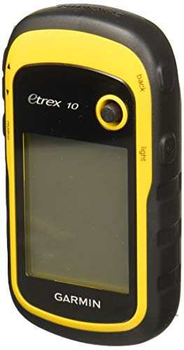
During this Garmin eTrex 10 review what immediately struck me is how distinctive-looking this black and yellow device is. It’s a small and compact unit with measurements of 2.1″ x 4.0″ x 1.3″, which is a good bit smaller than a standard-sized smartphone. It’s also light and easy to carry as it weighs only 5 oz (141.7 g) with the batteries installed. The device is surrounded by a thick plastic casing that has an ergonomically designed grip on the side. Along with its compact size, this makes it an easy machine to carry around on your hiking trips.
The eTrex 10 is a rugged and waterproof unit. It has an IPX7 rating that means it can survive being exposed to water for 30 minutes up to a depth of 1 meter. In reality, this means that it’s waterproof and can be used safely in the rain.
Display
The display is a 2.2″ monochrome (black and white) screen. It has a low resolution of 128 x 160 pixels that does not provide the detail and clarity of other more expensive devices. The good news, however, is that it’s easy to read, and the display is transflective, which means it’s entirely readable in bright sunshine.
Control Buttons
For those of you familiar with the eTrex range then you’ll know that they have a joystick type button on the upper right-hand side. This joystick is what you use to scroll through the various menu options. If you haven’t used one of these before then initially you might find it a little awkward. After a few days using the device, however, you should find that it becomes straightforward and, dare I say, intuitive to use.
Pro Tip: If you press and hold the joystick you can mark a waypoint
On the side of the unit, you also have some additional more traditional rubber buttons. These buttons allow you to zoom in and out on the screen and return directly to the main menu. There is also a ‘back’ button that brings you back a step and a power button that doubles up as a switch to adjust the light functions. Pressing this button allows you to change the backlight brightness – the higher the intensity then, the quicker the battery will drain. To save battery life, you should have the screen brightness set at a lower setting. If on the other hand, you press and hold this button, then the unit will power off.
As this is a button-operated device, it performs well in all weather conditions, including rain. You don’t get the responsitivity issues that plague some touchscreen handheld GPS devices when you try to use them in the wet. You can also use this device while wearing your gloves – although the compact size can at times make it a little fiddly.

Navigation
Straight up, I have to tell you about the elephant in the room. The eTrex 10 is a handheld GPS that comes with no mapping whatsoever. Yes, you read that, right, there are no maps included with the eTrex 10. What you do get is a Worldwide Basemap.
It can be challenging to plan your routes directly on the device as you’ll mostly be placing waypoints on a blank page. Not having a topographic mapping function on the device makes it advisable to pre-plan all of your routes at home. I’d recommend using the Basecamp software to plan your trip. Use the Track Draw feature to both plan and estimate the difficulty of your route. Once completed with the planning, you can transfer the details to your eTrex 10 using the USB cable. You can then choose the trip from the menu and follow the waypoints of the route until you arrive at your destination.
The Garmin eTrex 10 will store up to 50 routes, 1000 waypoints and a 100 tracks. It’s worth pointing out that this is all that you are going to be able to store on this device. There is only 6MB of internal memory available, and there’s no internal SD slot for some additional space.
GPS and GLONASS
By using both the GPS and GLONASS satellite systems simultaneously, the eTrex10 can obtain a better lock on your position. It is also faster in finding where you are as it has more satellites available to do so.
You can find out how many and which satellites you are using, by choosing ‘satellite’ in the main menu. This feature will tell you if you are using the GPS or the GLONASS systems. The screen will then provide you with the details of your location, the accuracy and the signal strength along with your current elevation.

GPS HotFix
The Garmin eTrex 10 is a highly sensitive device that finds your location quickly and accurately. It makes use of HotFix satellite predictions to find and obtain a satellite lock on your position faster. This method works by collecting your previous data and using this to predict your location. Using this system, you’ll find that it’ll take longer to obtain a fix on your location if you have moved thousands of kilometers from where you last used the device.
WAAS
The eTrex 10 also uses the Wide Area Augmentation System (WAAS) in North America, to provide better positional accuracy. The WAAS is a series of satellites and ground stations that combine to correct GPS signals. The result is that your location should be accurate to within 3 metres, over 95% of the time.
The Garmin eTrex10 does well in keeping a lock on your location when you’re out and about travelling. It will keep working even in some overgrown woods or in deep valleys.
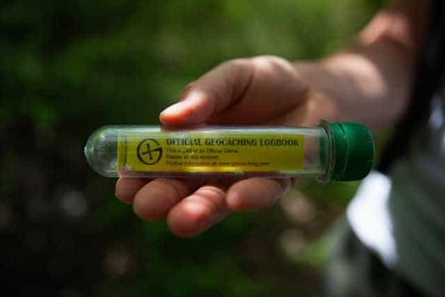
Geocaching
The eTrex10 is an excellent choice for those looking for a device to go paperless geocaching.
If you’re wondering how to add the Geocache GPX files to your Garmin, then this video below should help you out with its easy-to-follow step-by-step guide. Note that you will need a premium geocaching account to be able to use the ‘pocket query’ feature for bulk GPX transfers.
You will now have the Geocache details loaded onto the device. To get going is easy, find the GPX file and press ‘Go’. There is also the possibility of activating the chirp feature, which means the device will give an audible alarm when you are in the proximity of the cache. This feature is excellent, particularly as the eTrex 10 is so accurate in its location advice. You only have to hope that the original geocache coordinates are correct too!
Once you have found the geocache (or not, as the case may be) select ‘Geocache‘ in the menu and choose ‘log attempt’. Here you can log in your details about whether you found the cache or not (DNF). Once you have done this, you can add a comment or send a message to the cache owner that maintenance is required.
Digital Compass
The eTrex 10 has a digital compass that makes it easy to work out what direction you are going. For the compass to be accurate, you will need to keep moving for it to calibrate. Alternatively, you could hike using the compass as your navigation tool. On the screen, you will see a pointy triangle that will continue to point in the direction you want to travel. For it to work, you turn until the triangle on the compass points to the top of the device, that then is the direction you should travel to get to your destination head in that direction.
Battery Life
Expect to get around 25 hours of battery life from a couple of AA batteries. This time is impressive from an always-on device, but I guess having a lower resolution black and white screen is a significant factor in extending the battery life.
The benefit of using AA batteries is that not only are they cheap but it’s easy to carry a couple of spares with you. I would throw a couple of additional batteries into the bag for peace of mind.
Interface
As you might expect for an entry-level handheld GPS, the interface seems rather clunky and a little dated. As you fire up the device, you have a primary menu with six items. These include a map, a ‘where to’ feature, a compass and a trip computer. From this page, you can also mark a waypoint or delve into the settings page.
If I’m honest, despite being an easy to use device, the included documentation is somewhat lacking. The instructions don’t cover all of the features of the device. The best way to resolve this is to read the online documentation here, then head outside and try out the equipment. Give yourself a couple of hours, and you will work everything out and know how to use the device properly.
Check the Latest Price for the Garmin eTrex 10 on Amazon
Additional Features
Area Calculation
If you were wondering how large a particular field might be well, then you’re in luck! With this device, you can use the area calculation feature. Press start within the function, walk the field and then when you’ve finished the device will calculate the area for you.
Sun and Moon
As the name suggests, this function provides you with details and timings of the sun and moon. It lets you know when sunrise and sunset will take place based on your location. It also provides you with the same information for the moon. This feature can be useful if you want to make sure that you don’t get stranded out on the trail in the dark. If you’re like me, I’m guessing that you’ll want to get back to your car before darkness falls properly.
Hunt and Fish
This feature is probably self-explanatory. It provides you with the best dates and times for fishing and hunting in your current location.
Calendar and Alarm Clock
The calendar shows the month and the year on the top of the screen. Just like a standard calendar, you then get a monthly calendar showing the days and dates. The alarm clock feature could be useful if you are camping and need to get up early the next morning!
Calculator and Stopwatch
You’ll find these functions on the fourth and last page of the main menu. The calculator provides some scientific operations along with the standard calculator functions. Honestly, I have no idea what use you’ll make of a scientific calculator out on the trail, but it’s there if you need it! The stopwatch can be useful if you want to record some lap times on the trail.
Summary
In this Garmin eTrex 10 review, we’ve seen that this is an entry-level device that also happens to be one of the cheapest handheld GPS available. You’re not going to get all of the bells and whistles that come on more feature-heavy and pricier models, but you do get an excellent and reliable performer. The eTrex10 is small, light and robust enough to accompany you anywhere. You don’t get any detailed mapping but, it’s an accurate and easy to use device. It provides a great companion on a Geocaching hunt. In other words, it does what it does, and most importantly, it does it rather well.

Pros:
- Great Price
- Compact and Robust Device
- Excellent for Geocaching
- Fast and Accurate
- Easy to Use
- Long Battery Life
- Worldwide Basemap
Cons:
- No Mapping Included
- Monochrome Screen
- Documentation is Lacking
- Only 6 MB Internal Memory
- NO SD Card Slot
People also ask:
Can you download maps to the Garmin eTrex 10?
The Garmin eTrex 10 is designed to be as simple as possible to use and is best classed as a non-mapping handheld. It comes with the worldwide basecamp pre-loaded but you will not be able to load any additional mapping onto the unit. It’s also worth noting that this unit does not have any expandable memory slots.
If you’re worried about getting lost on the trail then don’t be! You can use the eTrex 10 to record and log the waypoints and the various tracks on your planned routes. This means you can always find your way back to where you started your trip.
How accurate is the Garmin eTrex 10?
Garmin claim that their devices are accurate to within less than 50 feet. Their handheld GPS range tends to have better accuracy and you should expect to log in to within 10 feet of your actual location. To be fair to Garmin, we’ve seen very little to dispute this fact over the years. The good thing is however, that you don’t need to take Garmin’s word for it as you can check the accuracy yourself.
How do you check the accuracy of your Garmin device?
The actual process of checking the accuracy of your Garmin GPS may differ slightly depending upon the device that you have. Thankfully however it’s pretty easy to do as all you’ll need to do is scroll through your device settings.
How can I ensure that my Garmin GPS remains accurate?
There are a few simple steps that you can take to ensure that your handheld GPS remains as accurate as possible.
Firstly, make sure that the software on the unit is completely up to date. You can do this by connecting your eTrex to your computer with the included cable and logging into your Garmin account.
Secondly, if you’re out on your travels and you think that the accuracy might be a little off, then keep moving. In our experience the Garmin has better accuracy if you’re moving and have a clear line to the sky. Also the eTrex 10’s compass direction will only work correctly when you’re moving.