That little sat nav unit that you have stuck to the windscreen of your car seems to be a little box of wonder. How on earth can such a small unit be able to tell us not only where we are but also what time we will arrive at our destination? It would appear to be a complicated bit of science that enables us to travel from A to B in an efficient manner. But is it really that complicated?
The Satellite Navigation System was originally designed for the US Military. The idea was that the system would change the face of modern warfare forever. It was designed to allow accurate pinpointing of troop and equipment locations. Their exact whereabouts and the distances between two points would be a very powerful tool for the future – a game-changer in military campaigns.
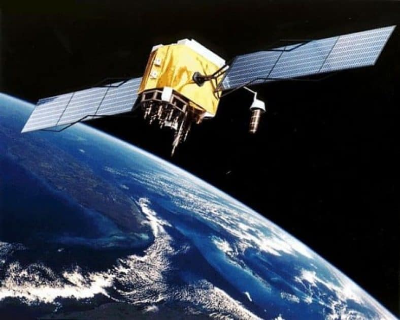
The Navstar system was launched in 1978 and the next 7 years saw a total of 24 first-generation satellites sent into orbit. Each satellite has a lifespan of around 12 years and they each orbit the earth at a distance of around 18,500 km. The various satellites have been both replaced and upgraded over the intervening years
The only difference between the military and civilian GPS systems is accuracy. The civilian system has a variance of around 12 metres, whilst the military version is accurate to within a few inches.
Following the shooting down of Korean Air Flight 007 after it had veered into Russian air space, Reagan decreed that the GPS system would be available to civilians. This would improve aviation safety for passengers as airlines could ensure that they kept on course at all times.
To this day, however, the system is still maintained by the US Military. As James May points out in the video, the US Military has the ability to turn off the system at will. If you find your GPS going blank one afternoon then perhaps there is a ‘Black Ops’ situation in your vicinity!
There are only 2 Global Navigational Satellite Systems (GNSS) in operation today. There is the GPS or Navstar system operated by the US Military and there is the GLONASS system operated by the Russian Military. There are other satellite systems currently being developed including the European Galileo system and the Chinese Compass system.
Satellite navigation, in essence, is fairly simple. Ok, the actual technology behind it all may be a little complicated but, the concept itself is relatively straightforward. We know that the Navstar system has 24 satellites in orbit. We also know that each satellite orbits the earth every 24 hours. Furthermore, each satellite contains a super-accurate atomic clock. This is the most accurate time and frequency available to us. This clock broadcasts both the time and location data to other satellites and to the clocks down here on earth.
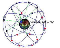
The satellite receiver reads and measures the data from the various satellites and compares them using a triangulation method. A triangulation system uses the angles of known points in order to pinpoint an exact location. The more satellites the receiver has a fix on then the more accurate the readings. The actual mathematics utilized in order to calculate location is not actually that difficult, but there are factors that do make it a little more complicated. The receiving unit will usually make some allowances for the satellites being constantly in motion and for the earth being an imperfect sphere in shape.
This same method of calculation is utilized by all GPS units including your car navigation systems, your running watches, and by your smartphones. The receivers may all be different sizes but they do all work on the same basis.
When I turn on my GPS watch before going for a run I have to wait until it finds the satellites and provides a “fix” on my location. In general, this takes around 20 – 30 seconds before it has located my position (the time this takes depends on where you are and what device you are using). Many devices today use a system of satellite caching in order to speed up the satellite acquisition process – it will find you quicker outside your home as it remembers your previous locations to an extent. Also, the more satellites that my device can see than the more accurate my location data.
In order to ensure that our vehicle satellite navigation units work correctly and safely manufacturers have introduced a number of other clever sensors.
- Accelerometer – it helps the sat nav understand it’s surroundings better. It can warn you when you are travelling too fast and are breaking the speed limit
- Compass – it helps with orientation, particularly when you are starting your journey
- Auto correct feature – the receiver will always presume that you are travelling on the road. If the readings are a little different then it will place you on the road for the purposes of navigation
- Inertial measurement unit – this is not in most receivers but when fully introduced to the market. This will allow receivers to work underground in tunnels or inside buildings
Hopefully, this article has explained a little of how that little box on your dashboard functions using the satellite systems orbiting the earth. It’s all pretty incredible when you stop and think about it……..and if you’d like to get one, then head over to our review page to compare the latest GPS devices.
I was in US Army Special Forces in the mid 1970’s, before they had GPS at the troop level. We used maps, a compass and a flimsy clear plastic protractor to determine our location.
Sometimes we would be accurate to within 10 meters. Other times we’d be a kilometer off depending on terrain and other factors.
The real difference was when we jumped from planes at high altitudes, 12,000 feet or more. A small error in the planes location could mean a days hike on the ground, being so far off we weren’t even in the map grid, never reaching our objective at all, or passing over dangerous obstacles like high voltage power lines at night, which actually happened.
By the early ’80’s US Air Force planes had sat nav systems and the difference in accuracy was dramatic, but I still like knowing I can navigate the old fashion way.
Hey there, thanks a million for sharing your story with us. Wow!
It’s amazing to think that you have real experience of how this technology impacted on peoples lives. It must have been not only more dangerous, but quite frustrating for you guys to be dropped some distance away from your destination. But I guess you guys just adapted, used your map reading skills and got the job done.
At that time,would the introduction of the sat nav have been a morale booster for the military personnel? Knowing that you would be dropped in the right location would certainly make the planning and execution of missions far easier.
Even today, technology is known to fail us at times. Most people today would be completely lost without their navigation devices. I believe that it’s important we know how to read maps & use a compass. I’d go as far as to suggest that it should be a mandatory subject in high school!
All the best, Dylan
This is an interesting article talking about the technology behind satellite navigation – and anything with James May in it is entertaining to watch. It’s amazing how dependent we’ve become on this technology – basically to find directions anywhere – just type it into your phone and go. Thanks for sharing this info on what goes on behind the scenes of our navigation systems.
Hi Jeff,
James May is always worth a watch! He gives information in his own style and it’s no wonder he’s a popular presenter. Top Gear is a favourite tv shows of mine. On that show however, and despite all of this sat nav technology we have today they seem to continually get lost in deserts etc 😉
Cheers,
Dylan
Fascinating! I knew that the GPS was developed by the US Military, but I didn’t know the details. I had no idea that it went back as far as 1978. Now I have more information to add to my application for Jeopardy one day 🙂 Just kidding. Absolutely fascinating post, and thank you for sharing.
Hi Tamara,
I think we’re all probably a little guilty of taking GPS technology for granted – it’s fascinating how it was developed and how it is now become an integral part of our everyday lives.
And who knows? Theses few facts may well come in handy for you when your on those quiz shows!
Good luck!
Hi Dylan, I had no idea that there were that many satellites in orbit, dummy me was thinking their was only a couple of them and couldn’t figure out just how they could locate you, so now I know. I was wondering, you said that they have a life span of about 12 years, what happens to them after that do they burn up in the atmosphere or are they still floating up there? All in all it is amazing how it all works and is now so ingrained into our daily lives, I sure do love technology.
Kim
Hi Kim, the technology to make it work is impressive stuff – like something out of a sci-fi movie!
Once a satellite has reached the end of life stage there are a couple of solutions available. It could be sent back down to earth, where it will burn upon re-entering the atmosphere. Alternatively it may be sent the opposite way and go further up into the orbit. Here it will continue floating around a safe distance away from the newer satellites on the block 😉
There are also some residual satellites up in orbit as the ground control system can only currently maintain a maximum 31 satellite constellation. With some future modifications perhaps some of these residuals could be brought back into service if so required in the future.
There are some images of so called “space junk” available and I’ll see if I can find one for a future post. It really is worth seeing!
Cheers
Dylan
Thanks Dylan for getting back to me, I was reading an article a couple of weeks ago, it was someone from NASA and he was talking about the space junk that is in the earths orbit, his concerns where that it will get to the point that there will be to much up there to launch any future rockets, with out colliding with them. Interesting stuff to say the least.
Kim
Hey Kim, in other words we may find ourselves surrounded by junk and unable to get off the planet! I guess mankind attitude towards waste really needs to change both down here and up there!
Really interesting article on how sat nav systems work ( inside the box so to speak! ). It’s the first time someone has explained this to me and it’s actually a lot easier to digest than I thought it would be! These days I’ve given up on the whole navigation thing and just use Google maps on my phone – seems to work just as well!
Hi Chris,
Even though it’s like something out of a science fiction movie the way satellite navigation works isn’t overly complicated. It really is a fantastic technology though, and I believe we’d be lost without it (no pun intended!)
Lots of people also use an app on their phone for navigation. I always say you have to pick what is the right device for you given your particular set of requirements.
Cheers,
Dylan
It is interesting to see the advanced technologies that are initially designed for warfare but then become very practical to the average consumer. Nobody likes war. I guess if there is something positive to pull from warfare it would be the technological advancements that emerge. However, I do wonder if these advanced technologies would result without the warfare. Perhaps, in a peaceful world, especially a world where educational opportunities were more equal, this type of technology would ‘naturally’ develop. I think I’ll do some research into this idea.
Great article. The difference in accuracy between the military grade and commercial grade systems is remarkably significant. Do you have any idea what the cost of implementing the military accuracy into the commercial system would be?
Thanks for this write up, most interesting, indeed.
Hey there, you raise an interesting point – would these technologies emerge without warfare? I’m guessing that this type of technology probably would be developed ‘naturally’. Warfare probably provides the impetus for these technological systems to be developed sooner rather than later. Wouldn’t it be wonderful if we had no need for warfare equipment?
To be honest, I have no idea how much it would cost to implement military accuracy to our sat nav systems. From what I have read it’s certainly very possible for high levels of accuracy to be provided. However, I gather that they won’t be allowing civilians to have access to their GPS due to safety reasons. They most certainly wouldn’t want their enemies or competitors also having their striking capabilities.
I’ve always been one to be interested the way things work, and this article was really informative on the mechanics and history of SatNav systems.
I’ve known the GNSS systems were developed by the US and Russian Militaries, but I had no idea the level of control they still hold over them today.
It was also quite fascinating to learn about the specifics of the sensors used in everyday SatNav systems.
Anyway, thanks for the interesting and informative post.
Many thanks for stopping by and I’m glad you enjoyed the article. 🙂
Thanks for all the info about Sat Nav systems. That is funny how you use equipment everyday without knowing how it works. Really interesting! I was hoping you could help as I do want to buy one. I would like to take it with me when I go on a Holiday, because you always have to pay extra at the car rental place for them. Which one do you recommend? I can use it in my own car and on holiday so that probably also means that the price of the Maps are also important.
Thanks Cees
Hi Cees,
There are a couple of things to consider before you choose which model to purchase.
1. The size of the screen – if your going to be carrying the device around with you it’s probably not a good idea to buy a device with the biggest screen on the market!
2. Maps – where are you going to be going on vacation? It’s probably best to purchase a device with Worldwide Maps rather than just North America or European.
For a budget option you can’t go far wrong with the TomTom Go 50 and you can check out my review of the device here. The Garmin nuvi 2555LMT is also a solid option as it includes Lifetime Maps and Traffic updates.
Drop me a line if you need any further assistance, I’d be delighted to help!
Cheers
Dylan
Hey a great post on GPS navigation systems. I worked as a Testing engineer long back for a Garmin so am familiar with most of the technology behind the scenes and I must say you have covered a lot of details. Also every time today i use anything, be it GPS or my phone I always think that what a fantastic thing ‘Accelerometer’ is, it has really changed our lives, what do you think?
Hey Ankit,
Thanks a million for dropping by and it’s great to hear from someone who used to work in the ‘industry’! I’d say that you got to look at some really cool stuff?
Your absolutely right that technology has changed our lives. The devices we all take for granted today to make our lives easier are amazingly clever. Being able to calculate the distance form one place to another, how to get there and the length of time it will take is fantastic. What has always fascinated me is the sat navs ability to recalculate your journey time if you go a ‘different’ route or run into traffic problems. It enables us to make decisions based on real tim information.
Cheers,
Dylan
I kind of like the idea that if my GPS is being weird then there must be some Black Ops activity in the vicinity.
With my GPS the way it is, there must be a BlackOps HQ somewhere where I live.
But seriously, I love the why about GPS, it’s a pretty amazing technology when you think about it.
I think I’d probably wet myself if a number of Black Ops descended into my vicinity! Imagine just driving along and then all of sudden your surrounded!
At least if you have a GPS device in the car you’ll receive advance warning of an operation!